While the
Google Moon shot in the last post is cool, and
Google Maps goes the next step in looking at the world and finding where you are, where you're going -
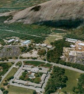
Google Earth is radically cool. Here's a shot of Stone Mountain, with "terrain" on to show the rock's altitude, rotated and tiled to show the Inn (bottom left corner), the Crossroads area where the kids played most of the vacation-time (bottom right side), and the field in front of the mountain where everyone crowded in for the evenings' laser shows. Most big cities are in high-resolution, and even when it's not that clear it's cool to see the terrain, find the landmarks around town, spin through the parking lots at the mall, mouse through the Main Street districts. You can turn on "buildings" to see the skyline in New York or Atlanta or any other metropolitan areas, again adding to the real fly-over feel of the program. It's a free download (fee for the plus-version, but I haven't seen a real need for it yet), and will hopefully help out with our kids' school geography stuff later - not to mention help us in planning next year's vacation excursion.
 While the Google Moon shot in the last post is cool, and Google Maps goes the next step in looking at the world and finding where you are, where you're going - Google Earth is radically cool. Here's a shot of Stone Mountain, with "terrain" on to show the rock's altitude, rotated and tiled to show the Inn (bottom left corner), the Crossroads area where the kids played most of the vacation-time (bottom right side), and the field in front of the mountain where everyone crowded in for the evenings' laser shows. Most big cities are in high-resolution, and even when it's not that clear it's cool to see the terrain, find the landmarks around town, spin through the parking lots at the mall, mouse through the Main Street districts. You can turn on "buildings" to see the skyline in New York or Atlanta or any other metropolitan areas, again adding to the real fly-over feel of the program. It's a free download (fee for the plus-version, but I haven't seen a real need for it yet), and will hopefully help out with our kids' school geography stuff later - not to mention help us in planning next year's vacation excursion.


2 Comments:
Jaw Dropping Sweetness! Too bad they hate us Apple users... maybe soon... :(
Wow...all those sites are so cool! I'm going to steal them from you and post them on my blog. =)
Post a Comment
<< Home